Our UAV-based magnetometer surveys deliver high-resolution magnetic data to reveal subsurface features, supporting mineral exploration, infrastructure planning, environmental studies, and archaeological investigations with safer, data-driven decision-making.
Data-driven UAV magnetic surveys reveal hidden subsurface features by measuring Earth’s magnetic variations, enabling safer and more informed decisions before excavation, drilling, or construction.
We support diverse industries with UAV magnetic surveys for subsurface detection, risk assessment, and large-area mapping.
High-resolution UAV magnetic survey capabilities delivering precise data acquisition, advanced processing, and reliable subsurface interpretation.
| Sensor Technologies | Optically pumped cesium vapor sensors for UAV surveys |
| Sensitivity Range | ~0.005 nT to 0.02 nT |
| Sampling Rate | Up to 1000 Hz for high-density magnetic data capture |
| Deployment Method | Fully drone-mounted magnetometer system |
| Positioning System | RTK/DGPS-enabled for precise spatial referencing |
| Coverage Capability | Suitable for large-area and high-resolution site surveys |
| Data Output | Total magnetic field, magnetic gradients, and anomaly maps |
From Precision Data Capture to Actionable Magnetic Insights
UAV magnetometer surveys are conducted using drone-mounted high-sensitivity cesium sensors with optimized flight planning and precise GNSS positioning. Survey grids, line spacing, and flight parameters are carefully designed to capture reliable magnetic data with minimal noise across large areas.
Key Points:
Collected magnetic data is corrected, filtered, and enhanced (diurnal correction, heading correction, noise filtering, and micro-levelling) to highlight meaningful anomalies. Processed outputs such as magnetic intensity and gradient maps are interpreted to identify subsurface structures and buried objects.
Key Points:
All processed results are delivered through a cloud-based platform for easy visualization, analysis, and GIS integration.
Key Points:
Receive complete deliverables, including stockpile volume repoComprehensive magnetic survey outputs delivering clear anomaly maps, target zones, GIS-ready datasets, and technical interpretation reports.rts, 3D models, and trend analysis. These reports are easily accessible through our dashboard, ensuring transparency and informed decision-making.
Key Points:
UAV magnetic surveys identify anomalies associated with subsurface lithology and potential ore bodies.
Use Case:
A UAV magnetometer survey is flown across the exploration area. The collected data is processed using corrections and filtering (diurnal correction, heading correction, noise filtering, and micro-levelling) to generate anomaly maps. These maps help exploration teams focus drilling on high-potential zones.
UAV magnetic data is used to map faults, dykes, lineaments, and lithological contacts across large areas.
Use Case:
Drone magnetic surveys capture variations in the Earth's magnetic field. Processed data is converted into structural interpretation maps to support geological analysis and planning
Drone magnetic surveys detect buried metallic infrastructure and subsurface obstructions before excavation.
Use Case:
A UAV magnetometer scan is conducted over the project site. Processed maps highlight linear and localized anomalies corresponding to buried utilities, supporting safe excavation planning.
UAV magnetic surveys detect subtle contrasts caused by buried archaeological features over large landscapes.
Use Case:
A drone magnetometer survey is performed across the heritage site. Processed data enhances shallow anomalies, helping identify potential buried structures before excavation.
UAV magnetic surveys identify buried metallic waste and landfill boundaries over large land parcels.
Use Case:
A drone magnetic survey detects anomalies associated with buried metal waste. Processed maps help environmental teams identify priority zones for investigation and cleanup.
Leverage advanced magnetometer survey solutions to gain reliable subsurface intelligence before your project begins.


Discover more ways Flybi Technologies can elevate your operations with tailored drone solutions.
Our numbers reflect trust and collaboration!
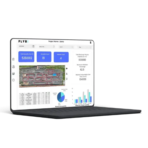
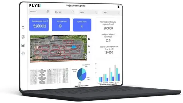
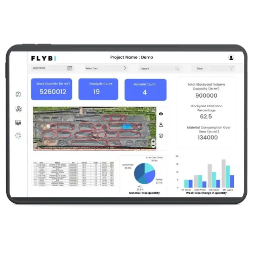
Effective stockpile management is essential for industries like mining, construction, and logistics. At Flybi Technologies, we bring precision and efficiency to inventory tracking using cutting-edge drone technology. Our advanced solutions streamline inventory processes, reduce waste, and improve operational decisions.
Why Choose Flybi for Your Measurement Needs?
High-Level Precision: We use advanced drone systems equipped with photogrammetry and LiDAR tools to provide highly accurate data. This ensures reliable calculations for any materials, from aggregates to minerals.
Efficiency in Data Collection: Traditional methods often require significant time and resources. Drone-based systems dramatically reduce this, enabling quick and precise measurements without delays.
Cost Savings: Flybi's approach minimizes operational costs by eliminating the need for extensive manpower or heavy machinery, offering a budget-friendly solution with no compromise on quality.
Safety First: Avoid risks by keeping personnel out of hazardous zones. Our solutions prioritize safety while complying with all operational guidelines.
Key Features of Our Services
Drone Integration: Using drones with high-resolution sensors and LiDAR, Flybi ensures comprehensive data capture with unparalleled accuracy.
Aerial Mapping: Our aerial techniques offer an overhead perspective, creating detailed 3D models and volumetric calculations of materials.
Detailed Reports: We provide actionable insights, from volume analysis to density distribution, giving businesses a clear overview of their assets.
Real-Time Monitoring: With up-to-date data, you can track inventory changes, predict trends, and make informed decisions quickly.
Applications Across Industries
Mining Operations: Precise inventory tracking allows better resource management and compliance reporting.
Construction Projects: Ensure material availability to keep projects on track without shortages or excess stock.
Logistics and Warehousing: Efficient management of bulk materials simplifies the supply chain and improves workflow efficiency.
Agriculture and Commodities: Monitor harvest yields, optimize storage, and ensure accurate assessments of bulk materials like grains or fertilizers.
Our Process
Consultation: Our team gathers information about your requirements, material types, and site conditions.
Drone Surveying: Advanced UAVs are deployed to collect high-definition images and detailed data of materials and their surroundings.
Data Processing: Collected data is processed into precise models and measurements using specialized software.
Customized Reporting: Receive comprehensive reports tailored to your operational needs, helping you analyze, plan, and execute efficiently.
Periodic Monitoring: For businesses requiring frequent updates, we offer continuous tracking to keep inventory data accurate over time.
Advantages of Flybi’s Solutions
Why Accurate Tracking Matters
Proper management of stored materials is vital for minimizing costs and maintaining operational efficiency. Inaccurate data can lead to overstocking, wastage, or missed opportunities, which directly affect profitability. Flybi’s services ensure precision, enabling better forecasting and resource allocation.
Industries We Serve
Mining: Track extracted resources and streamline production tracking.
Construction: Manage material flow efficiently and ensure continuity in large-scale projects.
Agriculture: Optimize storage and assess yield with accurate calculations.
Logistics: Simplify the handling of raw materials and finished goods.
Environmental Monitoring: Analyze and track storage impacts, ensuring sustainable practices.
Getting Started
Contact Flybi: Discuss your needs with our experts to design a tailored solution.
Custom Solutions: We adapt our services to meet the specific demands of your industry.
Seamless Process: From initial data collection to final reporting, we manage everything efficiently.
Actionable Insights: Use our detailed analytics to improve your business strategies.
Partner with Flybi for Advanced Inventory Solutions
Flybi Technologies delivers modern inventory management solutions using drone technology. Enhance your processes with precise, efficient, and safe measurement systems tailored to your needs.
Contact us today and redefine the way you manage your resources.
Most projects are completed within a day, with reports delivered in 48 hours.
Certainly! We offer periodic services for businesses needing continuous inventory tracking.
We can analyze various materials, including minerals, aggregates, grains, and fertilizers.
We provide data with accuracy within 1-2%, ensuring reliable volume and material tracking.
Yes, we adhere to all airspace and safety regulations during operations.